Property Record
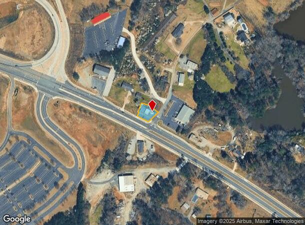
3997 Browns Bridge Rd, Cumming, GA 30041

NEARBY LISTINGS FOR SALE OR LEASE
-
-
View all Cumming listings for lease on LoopNet.com
Property Detail
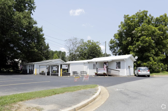
3997 Browns Bridge Rd
Atlanta-Sandy Springs-Roswell, GA
Linda W Heard Property
238-045
14-1 206-245
Commercialnec
Forsyth
X
Georgia
13117C0064G
206
2024
0.22 AC
2025
Cumming/Forsyth Cnty
130205
Atlanta
480 SF
DEMOGRAPHICS near 3997 Browns Bridge Rd
1 Mile
3 Mile
5 Mile
2024 Total Population
2,981
24,778
60,398
2029 Population
3,437
28,782
70,550
Pop Growth 2024-2029
+ 15.30%
+ 16.16%
+ 16.81%
Average Age
34
38
40
2024 Total Households
940
8,588
20,958
HH Growth 2024-2029
+ 15.32%
+ 16.27%
+ 16.89%
Median Household Inc
$112,500
$96,428
$101,022
Avg Household Size
3.00
2.80
2.80
2024 Avg HH Vehicles
2.00
2.00
2.00
Median Home Value
$342,255
$362,354
$385,128
Median Year Built
2006
2003
2000
Nearby Places
Map Layers
Map Styles
 Street
 Aerial
- Restaurants
- Banks
- Shops
- Fitness
- Groceries
SALE & LEASE HISTORY
LISTING DATE
SALE/LEASE

Oct 08, 2024
For Lease
Aug 15, 2018
For Lease
Nearby Properties
Address
Land Use
TOTAL SIZE
Lot Size
Zoning
Address
Land Use
TOTAL SIZE
Lot Size
Zoning
57,180 SF
61.71 AC
RES6
Address
Land Use
TOTAL SIZE
Lot Size
Zoning
28.74 AC
MP
Address
Land Use
TOTAL SIZE
Lot Size
Zoning
305,332 SF
23.75 AC
CBD
Address
Land Use
TOTAL SIZE
Lot Size
Zoning
413,484 SF
127.99 AC
A1
Address
Land Use
TOTAL SIZE
Lot Size
Zoning
98,743 SF
12.61 AC
CBD
Address
Land Use
TOTAL SIZE
Lot Size
Zoning
50,875 SF
420.29 AC
A1
Address
Land Use
TOTAL SIZE
Lot Size
Zoning
19.21 AC
M1
Address
Land Use
TOTAL SIZE
Lot Size
Zoning
152,668 SF
41.92 AC
CBD
Address
Land Use
TOTAL SIZE
Lot Size
Zoning
59,534 SF
16.93 AC
CBD
Address
Land Use
TOTAL SIZE
Lot Size
Zoning
74,796 SF
9.92 AC
CBD
Address
Land Use
TOTAL SIZE
Lot Size
Zoning
68,188 SF
121.31 AC
A1
Address
Land Use
TOTAL SIZE
Lot Size
Zoning
192,550 SF
21.11 AC
CBD
Address
Land Use
TOTAL SIZE
Lot Size
Zoning
17,657 SF
59.25 AC
A1
Address
Land Use
TOTAL SIZE
Lot Size
Zoning
80,956 SF
6.07 AC
CBD
Address
Land Use
TOTAL SIZE
Lot Size
Zoning
375 SF
154 AC
LR
Address
Land Use
TOTAL SIZE
Lot Size
Zoning
229.24 AC
M1
Address
Land Use
TOTAL SIZE
Lot Size
Zoning
80,497 SF
9.22 AC
CBD
Address
Land Use
TOTAL SIZE
Lot Size
Zoning
8,235 SF
5.65 AC
CBD
Address
Land Use
TOTAL SIZE
Lot Size
Zoning
12,217 SF
3.85 AC
CBD
Address
Land Use
TOTAL SIZE
Lot Size
Zoning
102,962 SF
20 AC
LR
Address
Land Use
TOTAL SIZE
Lot Size
Zoning
54,186 SF
26.64 AC
CBD
Address
Land Use
TOTAL SIZE
Lot Size
Zoning
69,200 SF
5.61 AC
CBD
Address
Land Use
TOTAL SIZE
Lot Size
Zoning
42.36 AC
CBD
Address
Land Use
TOTAL SIZE
Lot Size
Zoning
2,955 SF
5.88 AC
NS
Address
Land Use
TOTAL SIZE
Lot Size
Zoning
138.66 AC
A1
Address
Land Use
TOTAL SIZE
Lot Size
Zoning
33,608 SF
3.34 AC
HB
Address
Land Use
TOTAL SIZE
Lot Size
Zoning
40,092 SF
3.35 AC
M1
Address
Land Use
TOTAL SIZE
Lot Size
Zoning
3,060 SF
8.47 AC
M1
Address
Land Use
TOTAL SIZE
Lot Size
Zoning
1,595 SF
16.76 AC
CBD
Address
Land Use
TOTAL SIZE
Lot Size
Zoning
41,486 SF
6.11 AC
M1
The World's #1 Commercial Real Estate Marketplace
Connect with us
© 2025 CoStar Group
The information above has been obtained from sources believed reliable. While we do not doubt its accuracy we have not verified it and make no guarantee, warranty or representation about it. It is your responsibility to independently confirm its accuracy and completeness. Any projections, opinions, assumptions, or estimates used are for example only and do not represent the current or future performance of the property. The value of this transaction to you depends on tax and other factors which should be evaluated by your tax, financial, and legal advisors. You and your advisors should conduct a careful, independent investigation of the property to determine to your satisfaction the suitability of the property for your needs.